Geometry Basics
code chooser
This tutorial introduces the basic classes, methods, and functions of the geometry module. It focuses mainly on basic topics such as:
Construction and manipulation
Operations and analysis functions
Serialization and deserialization of geometry objects to and from various formats
Visualization
JTS
The JTS Topology Suite is in some way at the core of any Java application doing geospatial. It is the geometry engine upon which libraries such as GeoTools are built on. The GeoScript geometry module is for the most part a wrapper around JTS that adds some convenience functions making JTS more useful in a scripting environment. Which ultimately means that whatever you can with JTS you can do with GeoScript, only often with much less effort.
Geometry Objects
Geometry objects are constructed specifying sets of coordinates to the various Geometry constructors.
>>> from geoscript.geom import *

>>> Point(30, 10)
POINT(30 10)

>>> LineString((30,10), (10,30), (20,40), (40,40))
LINESTRING (30 10, 10 30, 20 40, 40 40)

>>> Polygon([(30,10), (10,20), (20,40), (40,40), (30,10)])
POLYGON ((30 10, 10 20, 20 40, 40 40, 30 10))

# polygon with hole
>>> Polygon([(35,10), (10,20), (15,40), (45,45), (35,10)], [(20,30), (35,35), (30,20), (20,30)])
POLYGON ((35 10, 10 20, 15 40, 45 45, 35 10), (20 30, 35 35, 30 20, 20 30))

>>> MultiPoint((10,40), (40,30), (20,20), (30,10))
MULTIPOINT ((10 40), (40 30), (20 20), (30 10))

>>> MultiPoint(Point(10,40), Point(40,30), Point(20,20), Point(30,10))
MULTIPOINT ((10 40), (40 30), (20 20), (30 10))

>>> MultiLineString([(10,10), (20,20), (10,40)], [(40,40), (30,30), (40,20), (30,10)])
MULTILINESTRING ((10 10, 20 20, 10 40), (40 40, 30 30, 40 20, 30 10))

>>> MultiPolygon([[(30,20), (10,40), (45,40), (30,20)]], [[(15,5), (40,10), (10,20), (5,10), (15,5)]])
MULTIPOLYGON (((30 20, 10 40, 45 40, 30 20)), ((15 5, 40 10, 10 20, 5 10, 15 5)))
js> var geom = require("geoscript/geom")

js> geom.Point([30, 10])
<Point [30, 10]>

js> geom.LineString([[30,10], [10,30], [20,40], [40,40]])
<LineString [[30, 10], [10, 30], [20, 40], [40, 40]]>

js> geom.Polygon([[[30,10], [10,20], [20,40], [40,40], [30,10]]])
<Polygon [[[30, 10], [10, 20], [20, 40], [40, 40], [30, 10]]]>

js> geom.Polygon([[[35,10], [10,20], [15,40], [45,45], [35,10]], [[20,30], [35,35], [30,20], [20,30]]])
<Polygon [[[35, 10], [10, 20], [15, 40], [45, 45], [35, 10]], [[20, 3...>

js> geom.MultiPoint([[10,40], [40,30], [20,20], [30,10]])
<MultiPoint [[10, 40], [40, 30], [20, 20], [30, 10]]>

js> geom.MultiPoint([geom.Point([10,40]), geom.Point([40,30]), geom.Point([20,20]), geom.Point([30,10])])
<MultiPoint [[10, 40], [40, 30], [20, 20], [30, 10]]>

js> geom.MultiLineString([[[10,10], [20,20], [10,40]], [[40,40], [30,30], [40,20], [30,10]]])
<MultiLineString [[[10, 10], [20, 20], [10, 40]], [[40, 40], [30, 30], [40, 2...>

js> geom.MultiPolygon([[[[30,20], [10,40], [45,40], [30,20]]], [[[15,5], [40,10], [10,20], [5,10], [15,5]]]])
<MultiPolygon [[[[30, 20], [10, 40], [45, 40], [30, 20]]], [[[15, 5], [40,...>
groovy:000> import geoscript.geom.*
===> [import geoscript.geom.*]

groovy:000> new Point(30,10)
===> POINT (30 10)

groovy:000> new LineString([30,10], [10,30], [20,40], [40,40])
===> LINESTRING (30 10, 10 30, 20 40, 40 40)

groovy:000> new Polygon([30,10], [10,20], [20,40], [40,40], [30,10])
===> POLYGON ((30 10, 10 20, 20 40, 40 40, 30 10))

groovy:000> new Polygon([[[35,10],[10,20],[15,40],[45,45],[35,10]], [[20,30],[35,35],[30,20],[20,30]]])
===> POLYGON ((35 10, 10 20, 15 40, 45 45, 35 10), (20 30, 35 35, 30 20, 20 30))

groovy:000> new MultiPoint([10,40],[40,30],[20,20],[30,10])
===> MULTIPOINT ((10 40), (40 30), (20 20), (30 10))

groovy:000> new MultiPoint(new Point(10,40), new Point(40,30), new Point(20,20), new Point(30,10))
===> MULTIPOINT ((10 40), (40 30), (20 20), (30 10))

groovy:000> new MultiLineString([[10,10],[20,20],[10,40]], [[40,40],[30,30],[40,20],[30,10]])
===> MULTILINESTRING ((10 10, 20 20, 10 40), (40 40, 30 30, 40 20, 30 10))

groovy:000> new MultiPolygon([[[30,20], [10,40], [45,40], [30,20]]], [[[15,5], [40,10], [10,20], [5,10], [15,5]]])
===> MULTIPOLYGON (((30 20, 10 40, 45 40, 30 20)), ((15 5, 40 10, 10 20, 5 10, 15 5)))
See also
See also
See also
Operations
Geometry objects offer a number of methods for calculating various properties including area, length, and validity.
>>> from geoscript.geom import *

# area
>>> poly = Polygon([(30,10), (10,20), (20,40), (40,40), (30,10)])
>>> poly.area
550.0

# length
>>> line = LineString((30,10), (10,20), (20,40), (40,40), (30,10))
>>> line.length
96.34413615167959

# validity
>>> poly.valid
True

# self intersecting polygon
>>> poly = Polygon([(1,1), (2,1), (1,0), (2,0), (1,1)])
>>> poly.valid
False
js> var {Polygon, LineString} = require("geoscript/geom");

js> // polygon area
js> var poly = Polygon([[[30,10], [10,20], [20,40], [40,40], [30,10]]])
js> poly.area
550

js> // line length
js> var line = line = LineString([[30,10], [10,20], [20,40], [40,40], [30,10]])
js> line.length
96.34413615167959

js> // geometry validity
js> poly.valid
true

js> // self-intersecting polygon
js> poly = Polygon([[[1,1], [2,1], [1,0], [2,0], [1,1]]])
<Polygon [[[1, 1], [2, 1], [1, 0], [2, 0], [1, 1]]]>
js> poly.valid
false
groovy:000> import geoscript.geom.*
===> [import geoscript.geom.*]

// area
groovy:000> poly = new Polygon([30,10], [10,20], [20,40], [40,40], [30,10])
===> POLYGON ((30 10, 10 20, 20 40, 40 40, 30 10))
groovy:000> poly.area
===> 550.0

// length
groovy:000> line = new LineString([30,10],[10,20],[20,40],[40,40],[30,10])
===> LINESTRING (30 10, 10 20, 20 40, 40 40, 30 10)
groovy:000> line.length
===> 96.34413615167959

// validity
groovy:000> poly.valid
===> true

// self intersecting polygon
groovy:000> poly = new Polygon([1,1],[2,1],[1,0],[2,0],[1,1])
===> POLYGON ((1 1, 2 1, 1 0, 2 0, 1 1))
groovy:000> poly.valid
===> false
Other operations such as intersection, union, difference, and distance calculate relationships between two geometry objects.
>>> from geoscript.geom import *

# distance
>>> point = Point(30, 10)
>>> point.distance(Point(40,30))
22.360679774997898

>>> line = LineString((30,10), (10,30), (20,40), (40,40))
>>> line.distance(point)
0.0

# intersection
>>> line.intersects(point)
True
>>> line.intersection(point)
POINT (30 10)

# union
>>> poly1 = Polygon([(0,0), (2,0), (2,2), (0,2), (0,0)])
>>> poly2 = Polygon([(1,1), (3,1), (3,3), (1,3), (1,1)])
>>> poly1.union(poly2)
POLYGON ((2 1, 2 0, 0 0, 0 2, 1 2, 1 3, 3 3, 3 1, 2 1))

# difference
>>> poly1.difference(poly2)
POLYGON ((2 1, 2 0, 0 0, 0 2, 1 2, 1 1, 2 1))

# symmetric difference
>>> poly1.symDifference(poly2)
MULTIPOLYGON (((2 1, 2 0, 0 0, 0 2, 1 2, 1 1, 2 1)), ((2 1, 2 2, 1 2, 1 3, 3 3, 3 1, 2 1)))
js> var {Point, Polygon, LineString} = require("geoscript/geom");

js> // distance
js> var point = Point([30, 10])
js> point.distance(Point([40, 30]))
22.360679774997898

js> var line = LineString([[30,10], [10,30], [20,40], [40,40]])
js> line.distance(point)
0

// intersection
js> line.intersects(point)
true

js> line.intersection(point)
<Point [30, 10]>

js> // union
js> var poly1 = Polygon([[[0,0], [2,0], [2,2], [0,2], [0,0]]])
js> var poly2 = Polygon([[[1,1], [3,1], [3,3], [1,3], [1,1]]])
js> poly1.union(poly2)
<Polygon [[[2, 1], [2, 0], [0, 0], [0, 2], [1, 2], [1, 3], [3, 3], [3...>

js> // difference
js> poly1.difference(poly2)
<Polygon [[[2, 1], [2, 0], [0, 0], [0, 2], [1, 2], [1, 1], [2, 1]]]>

js> // symmetric difference
js> poly1.symDifference(poly2)
<MultiPolygon [[[[2, 1], [2, 0], [0, 0], [0, 2], [1, 2], [1, 1], [2, 1]]],...>
groovy:000> import geoscript.geom.*
===> [import geoscript.geom.*]

// distance
groovy:000> point = new Point(10,30)
===> POINT (10 30)
groovy:000> point.distance(new Point(40,30))
===> 30.0

groovy:000> line = new LineString([30,10], [10,30], [20,40], [40,40])
===> LINESTRING (30 10, 10 30, 20 40, 40 40)
groovy:000> line.distance(point)
===> 0.0

// intersection
groovy:000> line.intersects(point)
===> true
groovy:000> line.intersection(point)
===> POINT (10 30)

// union
groovy:000> poly1 = new Polygon([0,0], [2,0], [2,2], [0,2], [0,0])
===> POLYGON ((0 0, 2 0, 2 2, 0 2, 0 0))
groovy:000> poly2 = new Polygon([1,1], [3,1], [3,3], [1,3], [1,1])
===> POLYGON ((1 1, 3 1, 3 3, 1 3, 1 1))
groovy:000> poly1.union(poly2)
===> POLYGON ((2 1, 2 0, 0 0, 0 2, 1 2, 1 3, 3 3, 3 1, 2 1))

// difference
groovy:000> poly1.difference(poly2)
===> POLYGON ((2 1, 2 0, 0 0, 0 2, 1 2, 1 1, 2 1))

// symmetric difference
groovy:000> poly1.symDifference(poly2)
===> MULTIPOLYGON (((2 1, 2 0, 0 0, 0 2, 1 2, 1 1, 2 1)), ((2 1, 2 2, 1 2, 1 3, 3 3, 3 1, 2 1)))
Operations such as buffer compute a new geometry object from an existing one.
>>> from geoscript.geom import *

# buffer
>>> line = LineString((30,10), (10,20))
>>> line.buffer(1)
POLYGON ((9.552786404500042 19.105572809000083, ..., 9.552786404500042 19.105572809000083))

# single sided buffer
>>> buffer(line, 1, singleSided=True)
POLYGON ((10 20, 30 10, 29.552786404500043 9.105572809000083, 9.552786404500042 19.105572809000083, 10 20))
js> var LineString = require("geoscript/geom").LineString;

js> // buffer
js> var line = LineString([[30,10], [10,20]])
js> line.buffer(1)
<Polygon [[[9.552786404500042, 19.105572809000083], [9.38688539962528...>

js> // single sided buffer
js> line.buffer(1, {single: true})
<Polygon [[[10, 20], [30, 10], [29.552786404500043, 9.105572809000083...>
groovy:000> import geoscript.geom.*
===> [import geoscript.geom.*]

// buffer
groovy:000> line = new LineString([30,10] , [10,20])
===> LINESTRING (30 10, 10 20)
groovy:000> line.buffer(1)
===> POLYGON ((9.552786404500042 19.105572809000083, ... , 9.552786404500042 19.105572809000083))

// single sided buffer
groovy:000> line.singleSidedBuffer(1)
===> POLYGON ((10 20, 30 10, 29.552786404500043 9.105572809000083, 9.552786404500042 19.105572809000083, 10 20))
See also
I/O
Geometries can be serialized in a number of formats. The I/O module supports reading and writing as Well Known Text, GML, KML, and GeoJSON are supported.
>>> from geoscript.geom import *

>>> point = Point(30, 10)

# gml
>>> writeGML(point, format=False)
u'<gml:Point xmlns:gml="http://www.opengis.net/gml" ><gml:coord><gml:X>30.0</gml:X><gml:Y>10.0</gml:Y></gml:coord></gml:Point>'

# kml
>>> writeKML(point, format=False)
u'<kml:Point xmlns:kml="http://earth.google.com/kml/2.1"><kml:coordinates>30.0,10.0</kml:coordinates></kml:Point>'

# geojson
>>> writeJSON(point)
u'{"type":"Point","coordinates":[30,10]}'
js> var geom = require("geoscript/geom");

js> // Well-Known Text
js> var wkt = require("geoscript/geom/io/wkt");
js> var point = geom.Point([30, 10]);
js> wkt.write(point)
POINT (30 10)

js> // GeoJSON
js> point.json
{"type":"Point","coordinates":[30,10]}
groovy:000> import geoscript.geom.*
===> [import geoscript.geom.*]

groovy:000> point = new Point(30,10)
===> POINT (30 10)

// gml
groovy:000> point.gml2
===> <gml:Point><gml:coordinates>30.0,10.0</gml:coordinates></gml:Point>
groovy:000> point.gml3
===> <gml:Point><gml:pos>30.0 10.0</gml:pos></gml:Point>

// kml
groovy:000> point.kml
===> <Point><coordinates>30.0,10.0</coordinates></Point>

// geojson
groovy:000> point.geoJSON
===> { "type": "Point", "coordinates": [30.0, 10.0] }
It is also possible to deserialize from these formats.
>>> from geoscript.geom import *

# gml
>>> readGML('<gml:LineString xmlns:gml="http://www.opengis.net/gml"><gml:coordinates>30.0,10.0 10.0,20.0</gml:coordinates></gml:LineString>')
LINESTRING (30 10, 10 20)

# kml
>>> readKML('<kml:Polygon xmlns:kml="http://earth.google.com/kml/2.1"><kml:outerBoundaryIs><kml:LinearRing><kml:coordinates>0.0,0.0 2.0,0.0 2.0,2.0 0.0,2.0 0.0,0.0</kml:coordinates></kml:LinearRing></kml:outerBoundaryIs></kml:Polygon>')
POLYGON ((0 0, 2 0, 2 2, 0 2, 0 0))

# geojson
>>> readJSON('{"type":"Point","coordinates":[30,10]}')
POINT (30 10)
js> var geom = require("geoscript/geom");

js> // Well-Known Text
js> var wkt = require("geoscript/geom/io/wkt");
js> var point = geom.Point([30, 10]);
js> wkt.read("POINT (30 10)")

js> // GeoJSON
js> geom.create(JSON.parse('{"type":"Point","coordinates":[30,10]}'))
<Point [30, 10]>
// gml
groovy:000> Geometry.fromGML2('<gml:LineString xmlns:gml="http://www.opengis.net/gml"><gml:coordinates>30.0,10.0 10.0,20.0</gml:coordinates></gml:LineString>')
===> LINESTRING (30 10, 10 20)

// kml
groovy:000> Geometry.fromKml('<kml:Polygon xmlns:kml="http://earth.google.com/kml/2.1"><kml:outerBoundaryIs><kml:LinearRing><kml:coordinates>0.0,0.0 2.0,0.0 2.0,2.0 0.0,2.0 0.0,0.0</kml:coordinates></kml:LinearRing></kml:outerBoundaryIs></kml:Polygon>')
===> POLYGON ((0 0, 2 0, 2 2, 0 2, 0 0))

// json
groovy:000> Geometry.fromGeoJSON('{"type":"Point","coordinates":[30,10]}')
===> POINT (30 10)
See also
See also
See also
Visualization
Often it is useful to be able to quickly view a rendering of a geometry object when doing some analysis. GeoScript provides functions for doing just this, located in a module named render.
The draw function accepts geometry objects, and an optional style, and renders the geometry. Styling is covered in a different tutorial.
>>> from geoscript.geom import *
>>> from geoscript.style import *
>>> from geoscript.render import draw
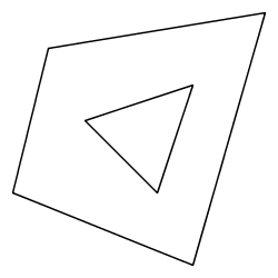
>>> poly = Polygon([(35,10), (10,20), (15,40), (45,45), (35,10)], [(20,30), (35,35), (30,20), (20,30)])
>>> draw(poly)
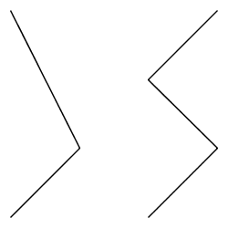
>>> line1 = LineString((10,10), (20,20), (10,40))
>>> line2 = LineString((40,40), (30,30), (40,20), (30,10))
>>> draw([line1,line2])
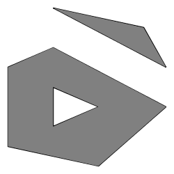
>>> poly = readWKT('MULTIPOLYGON (((40 40, 20 45, 45 30, 40 40)),((20 35, 45 20, 30 5, 10 10, 10 30, 20 35),(30 20, 20 25, 20 15, 30 20)))')
>>> draw(poly, Stroke() + Fill())
js> var viewer = require("geoscript/viewer")
js> var {LineString, Polygon} = require("geoscript/geom")

js> // draw a single geometry
js> var poly = Polygon([[[35,10], [10,20], [15,40], [45,45], [35,10]], [[20,30], [35,35], [30,20], [20,30]]])
js> viewer.draw(poly)

js> // draw multiple geometries
js> var line1 = LineString([[10,10], [20,20], [10,40]])
js> var line2 = LineString([[40,40], [30,30], [40,20], [30,10]])
js> viewer.draw([line1, line2])
groovy:000> import geoscript.geom.*
groovy:000> import geoscript.style.*
groovy:000> import static geoscript.render.Draw.draw

groovy:000> poly = new Polygon([[[35,10], [10,20], [15,40], [45,45], [35,10]], [[20,30], [35,35], [30,20], [20,30]]])
===> POLYGON ((35 10, 10 20, 15 40, 45 45, 35 10), (20 30, 35 35, 30 20, 20 30))
groovy:000> draw(poly)

groovy:000> line1 = new LineString([10,10], [20,20], [10,40])
===> LINESTRING (10 10, 20 20, 10 40)
groovy:000> line2 = new LineString([40,40], [30,30], [40,20], [30,10])
===> LINESTRING (40 40, 30 30, 40 20, 30 10)
groovy:000> draw([line1, line2])

groovy:000> poly = Geometry.fromWKT('MULTIPOLYGON (((40 40, 20 45, 45 30, 40 40)),((20 35, 45 20, 30 5, 10 10, 10 30, 20 35),(30 20, 20 25, 20 15, 30 20)))')
===> MULTIPOLYGON (((40 40, 20 45, 45 30, 40 40)), ((20 35, 45 20, 30 5, 10 10, 10 30, 20 35), (30 20, 20 25, 20 15, 30 20)))
groovy:000> draw(poly, style: new Stroke("black") + new Fill("white"))
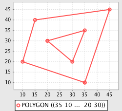
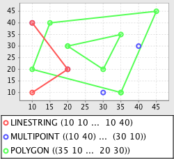
The plot function renders geometry objects similar to draw, but does so on a grid on which the axes are labeled. This gives a better idea of the exact scale and dimensions of the geometry objects.
>>> from geoscript.geom import *
>>> from geoscript.render import plot

>>> poly = Polygon([(35,10), (10,20), (15,40), (45,45), (35,10)], [(20,30), (35,35), (30,20), (20,30)])
>>> plot(poly)

>>> line = LineString((10,10), (20,20), (10,40))
>>> mpoint = MultiPoint((10,40), (40,30), (20,20), (30,10))
>>> plot([line,mpoint,poly])
groovy:000> import geoscript.geom.*
groovy:000> import static geoscript.render.Plot.plot

groovy:000> poly = new Polygon([[[35,10], [10,20], [15,40], [45,45], [35,10]], [[20,30], [35,35], [30,20], [20,30]]])
===> POLYGON ((35 10, 10 20, 15 40, 45 45, 35 10), (20 30, 35 35, 30 20, 20 30))
groovy:000> plot(poly)

groovy:000> line = new LineString([10,10], [20,20], [10,40])
===> LINESTRING (10 10, 20 20, 10 40)
groovy:000> mpoint = new MultiPoint([10,40], [40,30], [20,20], [30,10])
===> MULTIPOINT ((10 40), (40 30), (20 20), (30 10))
groovy:000> plot([line, mpoint, poly])
See also
See also
