Thematic Styling

This tutorial focuses on the creation of thematic styles. Tasks performed include:

  • Analyzing and classifying attributes of a layer

  • Building styles with multiple thematic rendering rules

Prerequisites

It is recommended that the Styling and Rendering be completed before proceeding, as it introduces the basic concepts of styling and rendering.

Classifying Attribute Data

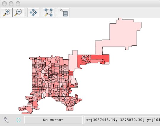
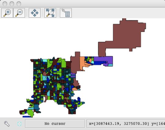
The Layer class contains a number of methods that can be used to analyze the distribution of layer attributes. Consider the cencus_boundaries layer that was loaded in a previous tutorial.

>>> from geoscript.workspace import PostGIS
>>> db = PostGIS('denver')

>>> census = db['census_boundaries']
>>> census.schema
census_boundaries [the_geom: MultiPolygon, SD_CDC_BND: float, PERIMETER: float, BLKGRP2000: long, BLKGRP20_1: long, STFID: str, STATE: str, COUNTY: str, COUNTYNAME: str, TRACT: str, BLKGRP: str, POP2000: int, POPDENSITY: float, WHITE: int, BLACK: int, AMERI_ES: int, ASIAN: int, HAWN_PI: int, OTHER: int, MULT_RACE: int, HISPANIC: int, MALES: int, FEMALES: int, AGE_UNDER5: int, AGE_5_17: int, AGE_18_21: int, AGE_22_29: int, AGE_30_39: int, AGE_40_49: int, AGE_50_64: int, AGE_65_UP: int, MED_AGE: float, MED_AGE_M: float, MED_AGE_F: float, HOUSEHOLDS: int, AVE_HH_SZ: float, HSEHLD_1_M: int, HSEHLD_1_F: int, MARHH_CHD: int, MARHH_NO_C: int, MHH_CHILD: int, FHH_CHILD: int, FAMILIES: int, AVE_FAM_SZ: float, HSE_UNITS: int, URBAN: int, RURAL: int, VACANT: int, OWNER_OCC: int, RENTER_OCC: int, SHAPE_AREA: float, SHAPE_LEN: float

The layer contains an attribute named “POP2000” that represents the total population of each census block. Using the histogram method it is possible to view the distribution of the population attribute.

>>> for classes,values in census.histogram('POP2000'):
>>> ... print k, v
    (0.0, 319.8) 21
    (319.8, 639.6) 29
    (639.6, 959.4) 144
    (959.4, 1279.2) 129
    (1279.2, 1599.0) 78
    (1599.0, 1918.8) 44
    (1918.8, 2238.6) 25
    (2238.6, 2558.4) 5
    (2558.4, 2878.2) 6
    (2878.2, 3198.0) 4

The histogram provides a set of intervals/classes that can be used to build up a thematic style for the layer.

>>> from geoscript.style import *
>>> from geoscript.render import *
>>> from random import randint

>>> style = Stroke()
>>> for classes,values in census.histogram('POP2000'):
...   fill = Fill(tuple([randint(0,255) for x in range(0,3)]))
...   style += fill.where("POP2000 BETWEEN %f and %f" % classes)

>>> draw(census, style, format='mapwindow')
../../_images/adv-theme1.jpg

Thematic Styles with Color Interpolation

The thematic style created from a random set of colors in the last section is far from visual appealing. What would be better is a set of colors forming a gradient with lighter values representing low population areas and darker colors representing higher population areas.

The interpolate function is used to interpolate intermediate values between two symbolizers.

>>> histo = census.histogram('POP2000')
>>> fills = Fill('#FFDFDF').interpolate(Fill('#FF4848'), len(histo))

>>> style = Stroke()
>>> for i in range(0, len(histo)):
...   style += fills[i].where("POP2000 BETWEEN %f and %f" % histo[i][0])

>>> draw(census, style, format='mapwindow')
../../_images/adv-theme2.jpg